
Set out with the goal of creating a Spot Elevation to be used with Volume Surfaces, that would automatically color code positive and negative elevation values. This idea has been addressed through the years, just giving it my spin on it.
First, started with a simple label and two label components with hardcoded colors. Components shifted out of the way for clarity:
• Positive + values to GREEN
• Negative - values to RED

Next, created two expressions that would show and hide text components, one for positive and one for negative values:
“Pos-Green”
Expression: IF({Surface Elevation}>0,0.01,0)

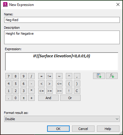
“Neg-Red”
Expression: IF({Surface Elevation}<0,0.01,0)
Then, return to the Label Style Composer for the Surface Spot Label style, set Text Height values to the previously created Expressions. The labels will show/hide based upon the positive or negative surface elevation values.
Hope you can use this simple application of equations to label components to control visibility. Please visit our other posts that review the use of more expressions:
- Volume Surface Spot Labels (Part 2)
- Alignment labels that flip out Part 1 and Part 2
- Disabling dynamic heights for annotations
- Expressing the curve delta
- Pipe labels 2d vs 3d slopes
About the Author
More Content by Leo Lavayen


